TERRAIN DESCRIPTION
Entering terrain descriptions into the profile
Methods of activation:
| icon: | menu: Tools > Terrain descriptions |
 |
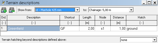
In the Terrain descriptions window, you can enter descriptions of the type of terrain under which the designed pipeline passes. In this way, you can mark e.g. roads, lawns, pavements, etc. on the profile drawing.
Terrain descriptions should be entered after entering data in Data table in program's main window. The accuracy of the entered numbers can be set in the Settings > Data table > Rounding window. The user can narrow down the number of descriptions presented in the editor by selecting the nodes between which they are located.
A description of each column in the table:
- Description - terrain description. Variables can be used in the description::
- @s - shortcut (Shortcut column)
- @l - length of described terrain (Length column)
- Shortcut - abbreviated site description, e.g.: GF for greenfield (if provided, appears in the table instead of the proper description). It is recommended to use it when the table cannot accommodate the proper description. If at least one abbreviation is entered, a legend explaining the abbreviation will be automatically placed on the drawing.
- Length - length of the described area.
- Node - name of the node (from the Data table), relative to which the distance to the beginning of the described terrain will be given. When editing this value the user must select a node from the list of already existing nodes. The description will be assigned to the selected node, i.e. the user can freely change its location in the Data table without having to update the location of the described terrain each time.
- Distance - the distance from the node in the Node column to the beginning of the described terrain. This value may be negative if it refers to a node that exists after the described terrain.
- Hatching - the hatch pattern of the terrain type applied under the existing terrain line.
The Description column has the ability to be quickly populated with user-defined names in the Settings window in the Most-used values section. By defining a description in the list, e.g. "Greenfield |GF" and selecting it, the Description ("Greenfield") and Shortcut ("GF") columns will be filled automatically.
From the list named Terrain hatching beyond descriptions defined above, you can select the hatching pattern that will appear under the line of the existing terrain in the entire profile (without definying in the table terrain descriptions), except for: sections defined as terrain descriptions, manholes, and manholes for septic tanks/tanks. From the list you can select:
- none
- ground (pattern: /// /// ///)
Current version:4.20
- Data table
- Data table - shortcuts
- Entering data
- Data exchange
- Network creating rules
- Searching data
- Profile parameters
- Crossings editor
- Protecting tubes editor
- Cross section editor
- Geological cross section
- Terrain description
- Boundaries description
- Additional ordinates
- Sewage treament plant
- Manholes
- Statistic
- Statistic - algorithms
- Materials' list