ADDITIONAL ORDINATES
Additional ordinates

Methods of activation:
| icon: | menu: Tools > Additional ordinates |
 |
In the Additional ordinates window, additional characteristic elevation points can be entered that lie outside the nodes entered in the Data table. These are usually locations through which the pipeline to be designed passes, with changing terrain, and at the same time do not require the selection of objects, i.e. the insertion of nodes in the Data table. Additional ordinates can be inserted for:
- existing ground level,
- projected ground level - the prerequisite for including the ordinates of the projected ground is to uncheck the option of autofilling the ordinates of the Projected ground level in the menu: Tools > Settings > Data table > Autofilling > Projected ground level,
- line 1,
- line 2.
Description of the individual columns of the table:
- Ordinate - the ordinate of an additional point expressed in m above sea level (a notation for a vertical step, e.g. 212.30/211.00, is also acceptable),
- Description - description to appear on the profile on a vertical point reference,
- Line - the line on which the additional point is to appear (to be selected from the above-mentioned list),
- Node - name of the node (from the Data table) relative to which the distance to the beginning of the described area will be given. When editing this value, the user must select a node from the list of already existing ones. The description will be assigned to the selected node, i.e. the user can freely change its position in the Data table without having to update the position of an additional point each time.
- Distance - horizontal distance from a node from the Node column to the additional point. This value can be negative if it refers to a node existing behind a point (looking in the direction of the profile drawing).
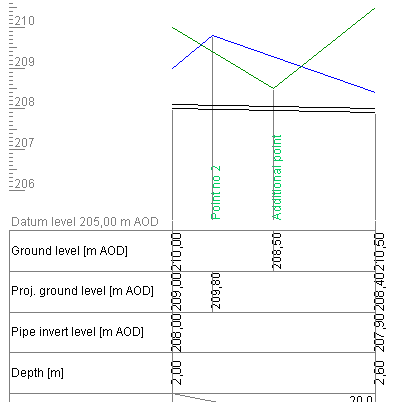
Below is an excerpt from the profile with additional ordinates points plotted.

Current version:4.20
- Data table
- Data table - shortcuts
- Entering data
- Data exchange
- Network creating rules
- Searching data
- Profile parameters
- Crossings editor
- Protecting tubes editor
- Cross section editor
- Geological cross section
- Terrain description
- Boundaries description
- Additional ordinates
- Sewage treament plant
- Manholes
- Statistic
- Statistic - algorithms
- Materials' list
