DATA TABLE - SETTINGS
Settings > "Data" table
Menu: Tools > Settings > Data Table > Table parameters
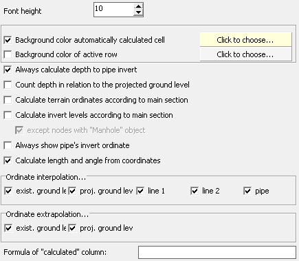
- By increasing the Font height value in the Data table, among other things, the readability of the data entered into it can be improved.
- By selecting the Background color automatically calculated cell, you can have the automatically calculated fields in the Data table 'highlighted'. The colour of the 'highlight' can be selected by clicking on the button in the currently selected color. Setting of color of active row is possible too.
- The pipe's depth in the Data table is calculated to the bottom, axis or top of the pipe (depending on the Pipe level as option selected in Panel on the Data tab). By checking the Always calculate depth to pipe invert field, the pipe depth is calculated always to the bottom of the pipe.
- When the option Count depth in relation to the projected ground level, the depth value is calculated as the difference between the ordinate of the design ground and the ordinate of the pipe. Otherwise the depth is calculated as the difference between the ordinate of the existing ground and the ordinate of the pipe.
- If the Calculate terrain ordinates according to main section option is selected, in a multi-profile project in which the main profile has been chosen, the ordinates of the existing ground and projected ground in connections diverging from the main profile will be automatically updated. This happens every time the user changes the ordinate of the ground in the main profile, even if it results from interpolation. Connections are identified by their node names.
- If the Calculate invert levels according to main section option is selected, in a multi-profile project in which the main profile has been selected, the pipe ordinates of the connections diverging from the main profile will be updated automatically. This happens every time the user changes the ordinate of a pipe in the main profile. The connections are identified by their node names. The ordinates are recalculated when in the Panel:
- on all connections the Pipe level must be selected as Value entered manually,
- both the main profile and the connections must have the same Pipe Network type set,
- the connections must have the correct Flow direction set
Manholes can be excluded from automatic updating by selecting the option except nodes with "Manhole" object. This may be necessary in the case of cascading sewer connections, for example. - When the Always show pipe invert ordinate option is selected, the bottom ordinate is displayed in the Data table in the Pipe ordinate column regardless of the selection in the Pipe level as option.
- With Calculate length and angle from coordinates option is checked, the fields in the Data table, Length and Angle, will be calculated from the node coordinates entered (only if two neighbouring nodes have different coordinates).
- Selecting the option from the group Ordinate interpolation... causes automatic determination of ordinate (if it has not been entered manually into the table): existing ground level, designed ground level, line 1, line 2 and pipe (if Pipe level is set in the Panel as manually entered value).
A prerequisite for automatic interpolation is the presence of a manually entered ordinate at any node before and after the node to be interpolated.
In addition, any number of ordinates can be interpolated simultaneously between nodes with already determined ordinates. To do this, press the Ctrl key on the keyboard and keep the Ctrl key pressed while holding the left mouse button down to select the nodes to be interpolated together with edge nodes with already defined ordinates. Then right-click on the selected area and select Interpolate between nodes.
- Selecting the option from the Ordinate extrapolation... group. causes automatic determination of ordinate (if it has not been entered manually into the table): of the existing terrain and of the designed terrain.
A prerequisite for automatic extrapolation is the presence of a manually entered ordinate at any node. For e.g. flat terrain, it is sufficient to enter the ordinate manually in only one node - the others will be filled in automatically.
For better orientation, nodes where the ordinates are interpolated/extrapolated are coloured differently from those where the value has been manually entered.
The Formula edit box of the Formula of "calculated" column allows you to define an expression using variables (starting @_td_) and numeric values. From the expression, its value is calculated, which is displayed in the calculation column of the Data table (Calculated column). E.g.: If you enter @_td_bottom_level as a formula, in the Data table the ordinate of the bottom of a manhole in a given node (if a manhole exists there) will appears in the Calculated column.